
Lancaster County, Leacock/Paradisehttps://directify.app/app/2294/projects/10553608/edit Townships. Built 1844. 178 ft long. One of 12 double-span, double-arch covered bridges in USA, pedestrian access only.

Lancaster County, Warwick Township. Built 1843, rebuilt 1973. 180 ft long. Lancaster County's longest single-span covered bridge, open to traffic.
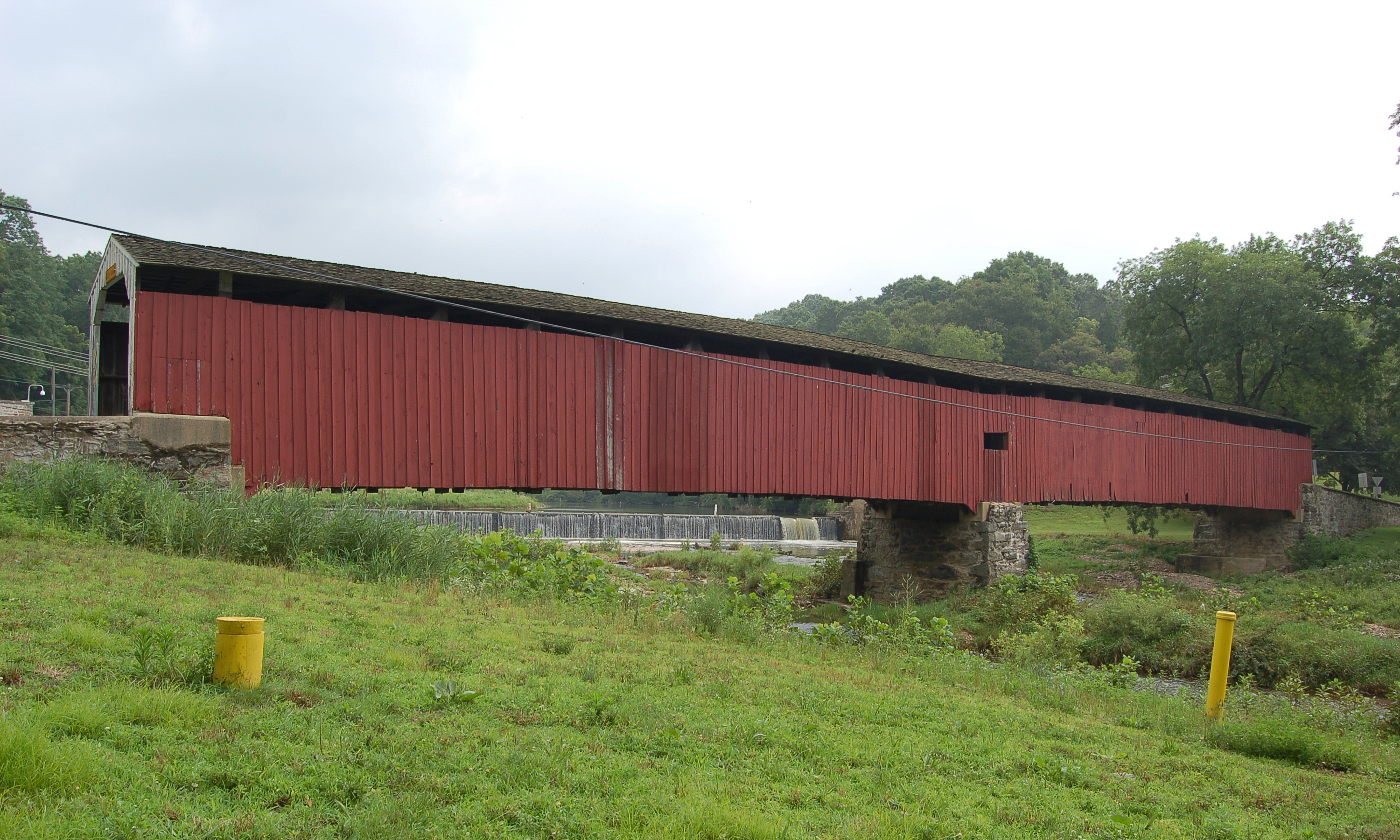
Lancaster County's longest single-span covered bridge at 180 feet across the Conestoga River. Originally constructed in 1843 to serve the thriving grain mill operated by the Hunsecker family, this magnificent structure witnessed nearly two centuries of Pennsylvania history.
The bridge's massive 180-foot span represents the pinnacle of Burr arch truss design, utilizing the innovative arch-and-truss combination that became Theodore Burr's lasting legacy to American bridge building. The original bridge served the community faithfully for 129 years before Hurricane Agnes devastated much of Pennsylvania in June 1972.
When unprecedented floodwaters reached the area, Hunsecker's Mill Bridge was torn from its stone abutments and carried downstream - a total loss that seemed to mark the end of an era. However, the local community refused to accept a modern concrete replacement. Through dedicated fundraising and lobbying efforts raising $85,000, residents convinced the Pennsylvania Department of Transportation to rebuild the historic bridge using traditional methods.
The reconstruction, completed in 1973, faithfully recreated the original design while incorporating modern safety features like steel support cables. Today, the bridge continues to carry traffic across the Conestoga, its weathered red siding and white portals serving as a beloved landmark.
The surrounding area retains its rural character, with Amish farms visible from both approaches. The bridge sits in a particularly scenic section of the river valley, where the Conestoga flows through rolling farmland dotted with silos and barns.
VISITING INFORMATION
The bridge is open year-round to vehicle traffic with a 10-ton weight limit. Parking is available at both approaches. The bridge is frequently crossed by Amish buggies, providing authentic cultural context for photographers and visitors. No admission fee.
Best photography occurs during golden hour with river reflections. Spring and fall offer optimal lighting conditions. Position on the north bank for morning light. Autumn foliage provides a vibrant backdrop with river views.
NEARBY ATTRACTIONS
Lancaster County Central Park (6 miles) Landis Valley Village & Farm Museum (8 miles) Kitchen Kettle Village (12 miles) Historic Ephrata Cloister (4 miles) Green Dragon Farmers Market (5 miles)
PRESERVATION HISTORY
Original bridge: 1843-1972 (129 years of service) Destroyed: Hurricane Agnes flood, June 1972 Community fundraising: $85,000 raised Rebuilt: 1973 by Lancaster County Method: Traditional techniques with original plans Modern additions: Steel support cables for load requirements Maintenance: Painting every 7-10 years, annual inspection by county engineers, timber replacement as needed using period-appropriate techniques
The bridge's survival and reconstruction represented a turning point in Lancaster County covered bridge preservation, demonstrating that these structures could be maintained as functional transportation links rather than merely museum pieces.
Lancaster County, Leacock/Paradisehttps://directify.app/app/2294/projects/10553608/edit Townships. Built 1844. 178 ft long. One of 12 double-span, double-arch covered bridges in USA, pedestrian access only.
Lancaster/Chester County Line. Built 1864. 198 ft long. Lancaster County's longest covered bridge, Civil War era construction, open to traffic.

Built in 1860, this 122-foot Burr Truss bridge spans Pequea Creek in Lancaster County, one of Pennsylvania's most scenic covered bridges.